
The Western U.S. megadrought
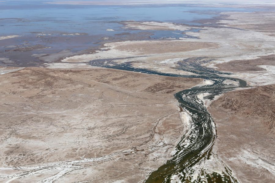
Image of dried up Colorado River Delta Source: https://www.nrdc.org/onearth/colorado-river-delta-proof-natures-resiliency
Since the year 2000, the Colorado River has declined almost 20% in size and volume, and today, no longer even reaches its natural delta in the gulf of California. It’s an unfortunate and saddening statistic, made only worse since this beautiful river has been exploited by the cities and towns in the west for years. This leads to a question. Why is the western U.S. using so much freshwater from the Colorado, and other rivers and lakes?
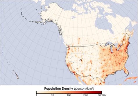
The United States is the 4th largest country in the world by area, and the largest in terms of global economy. It boasts a population of 338 million people. What is lesser known about the population is that over 80% of the total number of people in the U.S. live east of the line referred to as The Hundredth Meridian; a line going down the center of the mainland U.S. that splits the east and west. Even with California being the most populated state in the country, the Western U.S. only holds 20% of the total population, or around 78 Million people.
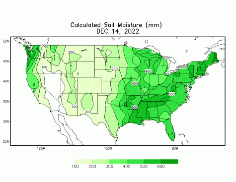
The reasoning behind this population difference could be attributed to a number of things, but the most pressing reason has to do with the vast mountain ranges that are scattered throughout the west, and their effect on moisture and rain (see maps below, and their correlation). The western U.S. is home to the Rocky Mountains, the Sierra Nevadas, the Coast Ranges, and many others. The only exception to this is the Pacific Northwest, where Seattle and Vancouver are, which are essentially walled in by the Cascade Mountains. Washington state is a model example showing how the mountains of the west are blocking moisture. Seattle, west of the Cascades, gets around 37 inches of rain a year, while Yakima, a city just east of the Cascade mountains, gets around 8.5 inches
On the other hand, the Appalachian mountains do not have this same effect on the Eastern US. This has to do with the heights that the Rockies, and other Western Mountain ranges boast. They make the Appalachians appear like small speed bumps in comparison. This, however, is a good thing, because it allows for moisture from the Atlantic and the Gulf of Mexico to flow into the East and provide heavy rainfall. The moisture in the east, compared to the drought in the west, is why far more people live in the east. Take Las Vegas for example; Las Vegas is a notoriously dry city, getting only 4.5” of rain per year. The city feeds off of freshwater from the Colorado River, and mostly, Lake Mead. Lake Mead has dropped 170 feet since 1983, the last and only time it ever flowed over the Hoover Dam. Bodies and shipwrecks are being recovered from the lake drying up, and Las Vegas has been restricted from drawing as much water as they have been from both the lake and the Colorado.
Cities in the Western U.S, like Las Vegas, Los Angeles, San Francisco, and others, are capable of overcoming the extremely dry west through their exploitation of freshwater in their local areas. Los Angeles only gets 1% of its water from recycled rainwater and water from their surface area, with 62% of it being imported from freshwater from rivers and lakes, and 37% from groundwater. There are solutions to the drought in the west that are being looked into, particularly the desalination of seawater; the process of removing salt from seawater to make clean drinking water.
Recently, California regulators have approved the creation of a desalination plant that could create over 5 million gallons of drinking water per day. The issue with desalination comes down to what to do with the salt. There’s not much to do with the salt, as the toxic brine and a chemical called boron can affect local agriculture, and in high enough amounts, boron can have effects on human health. Brine could be scraped off and used for things like epsom salts, but there isn’t a huge market for that, and actually manufacturing them costs more to do than it would yield profit. People argue that there is enough dead space in California where we can just dump the salt. They say that people certainly can’t dump it back into the ocean, as it would increase salt levels, which would in turn begin to negatively impact and kill marine life, similar to conditions seen in the dead sea.
There is also the fact that while many see it as a panacea, desalination is, at best, a flashy solution to the droughts happening in the west. It can have extremely negative effects on marine life in the ocean if the water is not drawn in carefully, or the salt is not dumped carefully. Desalination plants also require a huge amount of energy to operate. While they may seem like a good solution to improve drought conditions in the west, there are a lot of factors that go into them that make them not a worthwhile investment.
Back when the U.S. was expanding into the now western states, John Wesley Powell, the scientist who created the Hundredth Meridian back in 1878, realized that the west was extremely dry. He was far ahead of his time in his hypothesis and recognized quickly that if the government split the states into their proposed borders, water would be scarce and it would be difficult to regulate.
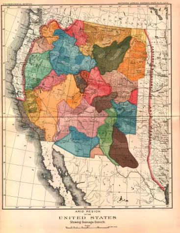
Powell proposed a solution: the US government split the states based on watersheds rather than the previous political borders. A watershed state would provide the cities and communities in the states water on how it could be supplied, so that the lakes and rivers would remain intact. Rather than listening to Powell, the US government simply ran with what they were doing, and have since paid the price for it.
The US currently is at a constant tug-of-war with itself. States were divided based on economics, railroads, rivers, and other ideological differences. Because of this, water distribution in the dry western US has been poorly regulated by the government. Had Powell’s solution been put into place, then the water content in these states would not only be restored, but would also provide enough water for the people living there. The extra water capacity would have the added benefit of increasing the population in the western half of the US, without risking a further water crisis. Unfortunately, the U.S. government opted for the most convenient option that would benefit them more quickly, as opposed to the option that would most benefit the people. Because of this, the Colorado river is suffering, and will continue to until the government finds a solution to the water crisis in the West.
Matthew Marsh is a freshman at the NYC iSchool. In his free time, he loves to play video games, write, and even draw on occasion.